Grampians (Gariwerd) National Park Fire Recovery
Project status
Updated July 2025
- Parks Victoria has completed initial risk and damage assessments across the park and is implementing a staged re-opening process for visitor sites.
- In the last three months Parks Victoria has delivered $1.88million of initial recovery works, focusing on critical biodiversity and urgent visitor site recovery in the fire area, including repairs to roads, walking trails and campgrounds.
- This means additional popular areas are reopening for visitors to enjoy including Mount Rosea Walk, Borough Huts Campground and Tunnel Walk.
- More sections of the Grampians Peaks Trail and hike-in campgrounds have reopened and are safe and accessible for visitors. You can view the full details listed here.
The project
The Grampians-Yarram Gap bushfire ignited on 17 December 2024, due to dry lightning, quickly spreading through the southern Grampians (Gariwerd) National Park.
Extreme weather and dry vegetation exacerbated the situation, affecting both the heritage listed national park and adjacent private lands.
Parks Victoria is leading a fire recovery project, working with other agencies as part of the whole of government recovery response.
The recovery project includes biodiversity works like predator control, ground feeding operations for the critically endangered Brush-tailed Rock-wallaby population, temporary habitat pods to shelter small native mammals and reptiles, deployment of remote monitoring cameras and assessments of the threatened plant species at risk.
Impact assessments, clearing debris from roads, walking tracks and visitor areas, and planning, scoping and rebuilding of park infrastructure continues.
Roads in fire impacted areas
It is expected that most of the roads within the National Park will reopen to the public by mid to late July. There will be longer term closures required for some roads, where significant damage has occurred and further essential works are required.
Background
The 2024-25 summer fires in the Grampians (Gariwerd) National Park had widespread impacts, resulting in the closure of some visitor sites including campgrounds, roads and walking tracks including sections of the Grampians Peaks Trail.
On 27 January 2025, additional fires ignited from another lightning band in the western area, burning large sections of the park, including Victoria Range, Victoria Point, Victoria Valley, and Wallaby Rocks.
In total, the fires burned 135,000 hectares—nearly 80% of the park—severely impacting biodiversity, cultural places, and visitor assets in the south-eastern, southern, and western areas.
Recovery efforts began as soon as possible, including predator control, habitat monitoring (Brush-tailed Rock-wallaby), and Blackfish relocation. Traditional Owners implemented strategic fire management to protect key cultural sites.
The fires also caused significant revenue loss for tourism businesses in the region. Forest Fire Management Victoria (FFMVic) and Parks Victoria are continuing impact assessments and stabilisation works, collaborating with Emergency Recovery Victoria, local government, and other agencies.
Acknowledgement
We acknowledge that the fire has affected the Country of the Djab Wurrung, Jadawadajali and Gunditjmara peoples who have occupied, cultivated and shaped the Gariwerd Landscape for thousands of generations. The Nationally Heritage Listed bio-cultural landscape reflects countless generations of skills, knowledge and culture.
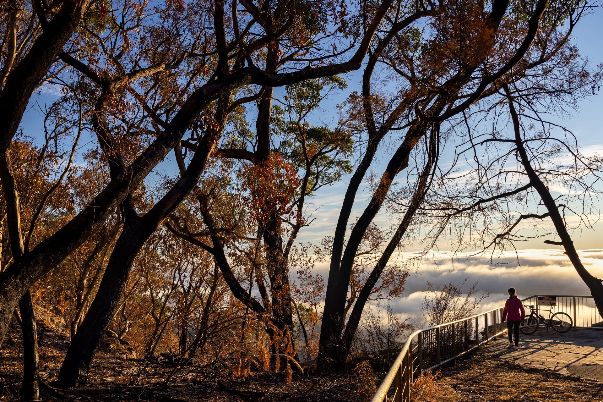
Boroka Lookout, Grampians (Gariwerd) National Park, February 2025
Project timeline
Fire and flood recovery projects are complex and can take time. The safety of staff and contractors working in the park is a priority as is ensuring natural and cultural values in the landscape can be properly identified, assessed and protected.
Parks Victoria is in the process of confirming recovery funding and insurance processes for the longer-term recovery effort. The focus of these efforts will be to ensure the staged re-opening continues and priority visitor sites are re-opened to the public as soon as it is safe and practical to do so.
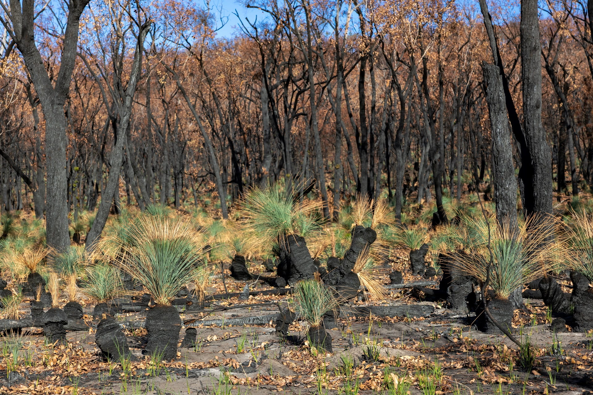
Fire-adapted plants like the native flowering grass trees (Xanthorrhoea) are regenerating after the fires.
Environmental Recovery
Biodiversity recovery programs commenced during the fire and will continue. This is to ensure the long-term recovery process for the landscape, wildlife and water. Pest animal control measures will continue including the control of deer, goats, foxes and cats.
The Grampians (Gariwerd) National Park is home to many endemic plants found nowhere else in the world. This summer's fires impacted many of these plants.
Visitors are reminded to stay on walking tails to help fragile plants recover and minimise soil erosion.
Managing Country Together with Traditional Owners
Parks Victoria are working with the Barengi Gadjin Land Council, Eastern Maar Aboriginal Corporation and the Gunditj Mirring Aboriginal Corporation during this recovery project.
Who are we working with?
Forest Fire Management Victoria, local shires, water catchment authorities and tourism agencies.
Access changes
Some fire affected areas of the park remain closed until they can be safely re-opened for visitors to experience whilst allowing the landscape to recover in the heritage listed National Park.
Many popular areas open for visitors to enjoy. For more detail visit the Grampians (Gariwerd) National park webpage, or Brambuk, The National Park and Cultural Centre in Halls Gap and speak with our friendly staff.
Related information
Grampians Ark project a lifeline for endangered native animals
Grampians (Gariwerd) National Park – An Inspirational Landscape for Travellers
Popular Parts of the Grampians (Gariwerd) National Park Reopen to Visitors
What’s Open in the Grampians Post-Summer Fires